View South Region Maps
The South Lakes (Postales andinas)

The provinces of Chubut, Neuquén and Río Negro have an appraised tourist treasure in the region of  “La cordillera Andina”  . Lakes, valleys, forests and mountains that they invite to an eternal contemplation. Thousand landscapes that conform a wonderful gift of the nature.

Lagos del Sur
San Carlos de Bariloche (prov. de Río Negro)

San Carlos de Bariloche, the main tourist destination in Río Negro Province and one of the main tourist destinations in Argentina, is located in the northwest of the Argentine Patagonia, at 770 meters above sea level, on the shores of Lake Nahuel Huapi. It is 1,680 kilometres away from Buenos Aires City.  The colours and hues of the landscape vary according to the time of year, with each season offering its own special surprise: sheer green in summer, ochre and yellow in autumn, multicolour in spring and stunning white in winter.  There is a full range of accommodation and shops in Bariloche, where the lifestyle blends the best features of big city and small village life. Bariloche is a melting pot of cultures, where the area’s native past, European culture and provincial customs converge. Its history is on show for all at the Patagonia Museum, overlooking the main square in the Civic Centre. 

There is a large number of events on Bariloche’s festival calendar. Some of the most outstanding are the traditional Snow Festival, involving sports competitions on Mount Catedral, a display of torch-bearing skiers swooping down the slopes in the evening, a fireworks display, a wood-chopping competition and the Snow Queen beauty pageant. Another typical event is the Navidad Coral Christmas concert, where the local children’s choir sings Christmas songs at the Bariloche Cathedral. Other events are the Wild Rose Festival (Fiesta de la Rosa Mosqueta), the European-Argentine and Latin American Community Festivals, and the National Curanto Festival celebrated in Colonia Suiza. All tourist activities take place in exceptionally beautiful natural surroundings. Many tours, such as those to Mount Tronador, Victoria Island and Arrayanes Forest, El Bolsón, Puerto Blest or San Martín de los Andes, have become traditional. In addition, there are alternative tours where you can learn about the typical plants and wildlife that inhabit each of the different ecosystems in the Nahuel Huapi National Park. You can add action to a sightseeing tour by doing trekking, rafting, skiing, horseback riding or any other of countless outdoor activities. And, of course, Bariloche also offers the tourist a number of pubs, snack bars, restaurants and discos. However, holidays are not the only reasons for visiting Bariloche. The area is also perfect for congresses and incentive programme trips.  Bariloche offers a wide variety of local handcrafts. Chocolates and smoked foods are a classic, both in Argentina and abroad. In addition, there is an almost endless variety of products ranging from beer to natural cosmetics made from wild rosehips and lavender, pottery, candles, knitted garments, preserves and carved wood.

NAHUEL HUAPI National Park:  The Nahuel Huapi National Park and Reserve covers a total area of about 710.000 hectares. It was created in 1934 to protect representative natural environments in the Andean region of north Patagonia, provide opportunities for recreation and tourism, and establish a veritable natural laboratory for scientific research.  Some of its most outstanding features are the lakes and fast-flowing rivers fed by snowmelt and plentiful rainfall, whose waters ultimately flow into the Atlantic or Pacific Oceans. Lake Nahuel Huapi is the largest, with a surface area of 600,000 hectares. It has several arms, such as Ultima Esperanza, Rincón, Blest, Tristeza and Angostura, among others, and large peninsulas of extraordinary beauty, such as Llao-Llao, Quetrihué, San Pedro and Huemul. Our history and our people : The Nahuel Huapi area has a legacy of different histories, cultures and ethnic groups. Its original inhabitants included Tehuelches (hunter-gatherers), Puelches (lakeside dwellers) and Araucano groups (agricultural).
The aboriginal population witnessed the arrival of white men from Chile during the 17th, 18th and 19th centuries, as members of Jesuit Missions, slave raids and military incursions, or as travellers. In the end, the Conquista del Desierto – Desert Conquest – led by General Julio Argentino Roca in 1883, disbanded the native groups which lacked cohesion at the time and could only attempt to defend themselves, thus strengthening white man’s presence in the region.
The first Argentine to reach the shores of Lake Nahuel Huapi was Francisco Pascasio Moreno in 1875. He became friend, as well as prisoner, of Cacique Sayhueque, the legendary chief of the “Apple Country”. Moreno travelled the whole area on successive journeys, and his work was to become essential to Argentina and Patagonia, as it was decisive in determining the frontier with Chile.  In return for his work, the government awarded Moreno lands, which he went on to donate in 1903 for the creation of Argentina’s first national park: Parque Nacional del Sur, later renamed Nahuel Huapi. Colonia San Carlos, known today as San Carlos de Bariloche, was founded in 1902.  After the creation of the Nahuel Huapi National Park and the arrival of the railway in 1934, the farming activity that had prospered at the beginning of the 20th century was left aside, and tourism began to develop. Today, Bariloche reflects a mixture of old indigenous cultures and European influence.
Climate: The Nahuel Huapi National Park is situated within continental cold with a dry season zone. Neither the temperatures nor the precipitation are uniform in the area occupied by the Park. An ample variation in rainfall occurs from east to west, between the border with Chile and the Limay river. On the other hand, temperatures decrease as we move uphill.  In winter, the average temperatures are of 2ºC and in summer of 18ºC. The average yearly rainfall in Puerto Blest is of 3,000 mm , while in Bariloche it is of 1,100mm.  Summer ( dec-feb) Warm sunny days with cool nights and scarce rainfall. Winds predominantly from the SW. Because of the latitude at which the city of Bariloche is situated, daylight extends up to around 10 p.m.  Autumn ( mar–may) Cool days and cold nights. Temperatures vary between 4ºC and 13ºC. Predominantly intense rainfall.  Winter ( jun-aug) Cold days and snowfall. Temperatures vary between 0ºC and-10ºC.  Spring ( sept-nov) Cool days that start getting longer. Temperatures slowly increase while rainfall decreases. Cold nights. During the day temperatures vary between 7ºC and 20ºC towards the end of the season.

VICTORIA ISLAND and ARRAYANES FOREST: The tour begins at Puerto Pañuelo, the harbour located 25 km. out of town, opposite Hotel Llao Llao. You can get there by bus or drive your own car. The boat sails over Lake Nahuel Huapi for 30 minutes to Puerto Anchorena at the island’s narrow central area.

PUERTO BLEST, LOS CÁNTAROS CASCADE, LAKE FRÍAS: Set sail from Puerto Pañuelo to the Blest arm of Lake Nahuel Huapi. On the way, the boat passes Centinela Island, where Fransisco P. Moreno, creator of Argentine National Parks, is buried. An hour later, the boat reaches Puerto Cántaros.

MOUNT TRONADOR by LAKE MASCARDI: Get to the Villa Mascardi pier by driving past Lakes Gutiérrez and Mascardi along Route 258. A boat sails over the clear, green waters of Lake Mascardi to the Tronador arm, arriving at Hotel Tronador, with its backdrop of Mount Tronador, for lunch. Then drive along the Manso River valley to Pampa Linda and the Ventisquero Negro glacier.

CIRCUITO CHICO (SMALL CIRCUIT): Circuito Chico is a scenic route along which you will enjoy both the scenery and the flavours. There are beautiful views all the way, which you can stop to admire at several points and natural lookouts such as Bahía López (López Bay) and Punto Panorámico (Panoramic Point).  A chairlift at Km. 17 carries you up to the top of Mount Campanario with its wonderful bird’s-eye view of the area. Several teahouses and restaurants offer delicious meals and snacks to add flavour to the tour. Hotel Llao Llao, San Eduardo Chapel and the harbour called Puerto Pañuelo are special attractions, as well as the traditional Colonia Suiza village. In addition to the scenery, Circuito Chico has more to offer: you can buy knitted goods, candles and a variety of other handcrafts. You can also take a peaceful walk through the woods along easy footpaths in the Llao Llao Municipal Park.
Operating times: daily/year round 
Duration: half day.

MOUNT CATEDRAL: Catedral is the largest Ski Centre in the Southern Hemisphere, offering a wide range of winter sports facilities and fantastic scenery. There are various ski lifts and cable cars, open all year round.  Hotels, restaurants and a variety of shops will satisfy the tastes and needs of the large number of skiers and tourists who visit the area each year. In summer, you can take part in different outdoor activities to fully enjoy the natural surroundings on the wooded slopes of Mount Catedral.
Trip: 45 km.  Time: half-day

civico
catedral2
catedral
circuito chico
7lagos
villa
tronador
isla vic


CONSULT!!!


San Martín de los Andes (provincia de Neuqén)
Population head of Parque Nacional Lanin. Located on the North coast of Lago Lácar,  characterizes by its hoisted streets and constructions of wood with ceilings to two waters, that look like the alpine streets of Europe. Their main attractions are: lacustrine excursions by Lago Lácar, the near Chapelco Hill, where in winter works like a concurring skii complex; and Lago Huechulafquen, dominated by the image of Lanín volcano, that crater - now extinguished - is to 3,774. mts. of height.
San Martín

CONSULT!!!


El Trochita
It was inaugurated in 1945, and at present is a real attraction for the fanatics of the railroads. It was called “El Trochita” because travels on an economic way, of only 75 cm. of wide. The trip covers 402 Km. between Ingeniero Jacobacci and Esquel, by the Patagonian plateau among levels that go from the 600 to the 1.200 mts. above sea level. Besides, the railroad travels through 626 curves, a bridge of 105 mts.  (on the Río Chico) and a tunnel that extends for 110 mts. In its golden epoch "El  Trochita" transported until 25 thousand tons of load, product of the textile and cattle activity. Today is only used for tourist ends. It is carried by a Henchel locomotive, created in 1922 in Germany that covers the trip with a speed of 29 km/h. The wagons, that are of same epoch, has a heating system by salamandras that the same passengers feed with coal. 
Trochita

CALAFATE Rivers of Ice

The town of Calafate is located at the riverside of the Argentinean lake and it is the southern access to the fabulous  National Park , that covers 600.000 hectares of lakes, glaciers and spectacular mountainous chains.
“Calafate” took the name of a bush of yellow flowers and eatable fruit that  is common see it in the south of Patagonia. 
The glacier Perito Moreno is one of the biggest natural shows in South America and it is one of the few that is still growing. It slips to a speed of 100 meters per year. In this advance they come off blocks of ice of great size that fall toward  the waters of the lake with a roar that you can hear from kilometers of distance. In an approximately 3 year-old cycle the glacier ends up dividing the lake in two interrupting the bed of the Rico arms and Sur.
This makes that the flow grows until having a difference of height with the Argentinean lake of 35 meters. The potent pressure of the water breaks the ice in 48 or 72 hs. and the water of the arms precipitates throught the opening of gigantic waves. An unique and impressive show that happened, after 16 years in  March 12, 2004.
 

perito
glaciar

CONSULT!!!


Tierra del Fuego Trip to the end of the world


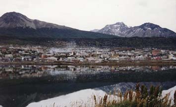
Capital of the Province of Tierra del Fuego, Ushuaia is the southernmost city in the planet.
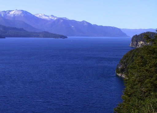
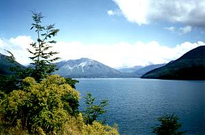
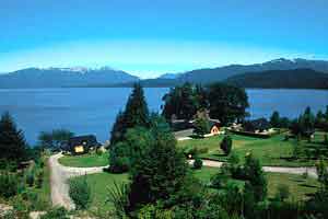
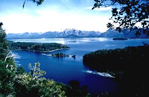
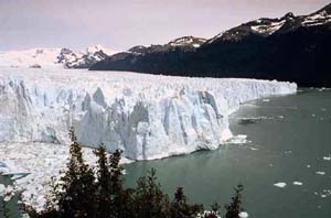
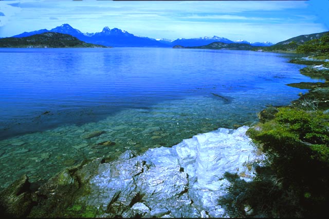
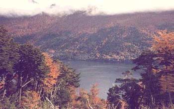
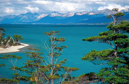
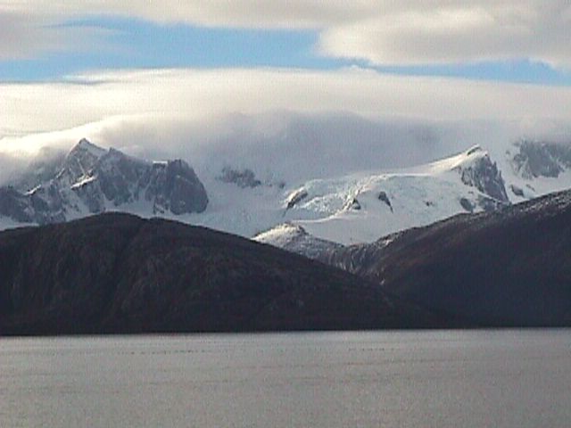
Ushuaia -which in the yámana language means “bay overlooking the West”- is surrounded by Mount Martial to the West and by Mounts Olivia and Cinco Hermanos to the East. Located on the shores of the Beagle Channel, it offers a unique landscape, which combines mountains, sea, glaciers and forests.  With a whimsical geography, Ushuaia has adapted its features to modern construction, thus developing a very quaint city. It has a very good hotel and gastronomy infrastructure which pleases the expectations of international visitors.
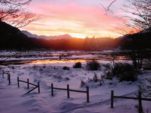
As a result of its location, close to the South Pole, in the summer it has approximately eighteen hours of light , whereas in the winter, it only has seven or eight.
An emblematic tourist destination, Ushuaia allows the practice of adventure travel: hiking, horse-riding excursions, mountain biking, sport fishing and the most spectacular voyages along the Beagle Channel and across the Tierra del Fuego National Park in the Lapataia Bay.
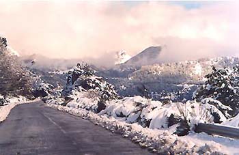
In the winter, the landscape changes its physiognomy and the days are generally bright and clear.
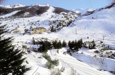
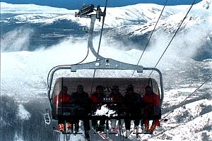
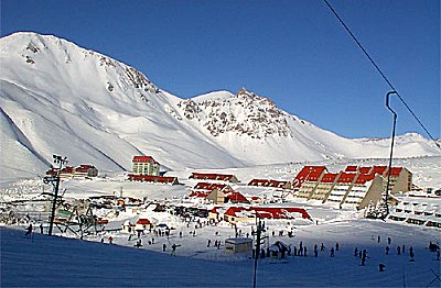
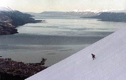
Among its winter resorts, Mount Castor stands out, where Nordic and Alpine skiing can be practiced. With its modern lifts, it has one of the best schools in the country.
Its people, its origins, its mysticism and its nature are discovered in every step we make.

HISTORY

USHUAIA: the end of the world, the beginning of everything.
The aboriginal population was formed by Onas or Selknam and Yaganes or Yamanas and only at the end of the XIX century, European sailors started raising cattle in the area.
The Selknam were essentially terrestrial hunters and nomad fruit gatherers who lived on the island of Tierra del Fuego from the plains near the Strait of Magellan to the area betwen the river Grande and the Beagle Channel. They called their land Karukinka.
At the beginning of the XX century there were only some survivors scattered around the forests, or sheltered by Salesian Missions and by the Bridges family.
In the first decade of the century, Salesian priests estimated there were no more than 350 Selk´nam. On 9th October 1966 died Lola Kiepia, and Angela Loij, one of the last Onas who kept speaking the language, in 1974.
The Selk´nam ate guanacos and coruros, a kind of rodent, as well as foxes, birds, wild berries, and sea products. They lived in tents or in conical huts.
The Yámanas or Yaganes lived on both sides of the Beagle Channel and the adjacent channels up to Cape Horn, near the sea. They hunted sea wolves, one of their main food sources. Their body was long and wide in contrast to their inferior limbs.
During the incursions of European sailors in the XIX century, The Yamanas were taken by surprise by the brigantine Beagle, after which the channel was later called. Thus were initiated the first contacts with white men.
After more than 6000 years of living in the area, the inhabitants farthest south on the planet started receiving European explorers, a moment when there were shipwrecks, combats, sea lions hunting, factors that contributed to deteriorate their life style.
In 1881started the exploitation of gold in the territory. Miners settled in the north of the island got in contact with the Selk´nam and ill-treated them, what caused their violent reaction.
The Rumanian Julio Popper arrived to Argentina in 1885 and settled in El Páramo, in Tierra del Fuego in 1888. He exploited gold, and achieved power, success, and influence in the area. He even coined his own currency, a postage stamp, and created a small private army .
In 1871, the Anglican mission in charge of reverend Thomas Bridges settled in the peninsula where the airport is today.  On 18th June 1872, Tomás Despard Bridges was born on the island, the first white Fuegian baby.
In September 1884 the expeditionary division to the South Atlantic of the Armada Argentina commanded by Comodore Augusto Laserre landed in Ushuaia, and on the 12th October they raised the Argentine flag in the newly built subprefecture. Every year that date is celebrated as the birth of the city.  By presidential decree, the 27th June 1885, Ushuaia was appointed capital and see of the government of Tierra del Fuego. 
Pioneers arrived attracted by commentaries on the existence of gold in the area. But the central government was interested in permanent residents, and so took as an example the policy of countries like France and Britain to build a prison in the archipielago. It was first built in States Island, and then in Bahía Golondrina, near Ushuaia, in 1902. It marked the characteristics of the city during the first half of the century.
Since the main supply center was very distant, they had a press, a photography lab, shoe makers, bakers, medical service, and chemistry to cover the needs of the population.
At the beginning of the century, many Lituanian, Libanese, Spanish, and Croatian families came to Tierra del Fuego for different reasons. Once they finished their work, many of them decided to stay.

In 1947 the central government closed the prison, and the building was acquired by the Ministery Of Marine to create in 1950 the Base Naval Ushuaia Almirante Berisso.
The seventies marked another moment in the history of the city. Law 19.640 of industrial promotion was passed and many Argentinians from different provinces were attracted by the possibility of working and saving. Since then, Ushuaia´s population has been constantly increasing

EXCURSIONS

USHUAIA
The days are longer among the months of September, October and November. it dawns between the 07.30 and the 08.00 hs. and it is dark between the 20.30 and 21.00 hs. December is the month of more solar light, dawning between the 02.30 and 03.00 hs. and darkening between the 23.30 and 24.00 hs. From half-January the days begin to be shorten.

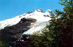
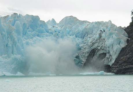
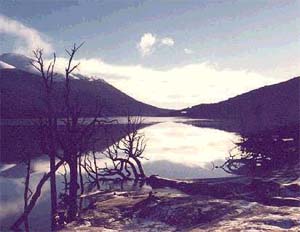
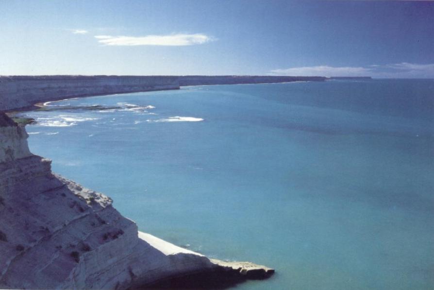
NATIONAL  PARK of TIERRA del FUEGO: It is located only from 11 Km. of the city. we will be able to see inside its limits lakes, lagoons and rivers, and its exit toward the Beagle channel, characteristic that differentiates it from other National Parks of Argentina.From the port, to the Southwest, it will be transited by the outskirts of the city until arriving to the Mount Susana, witness of the work of the convicts of the old prison, where it is located the station of the “Fueguino Southern Railroad”. Then, you  continues along the valley of the Pipo River until the deviation to enter at Ensenada bay, where one will be able to contemplate the Redondo and Estorbo Islands and in the way to the other coast of the Beagle channel the Snowy Mounts of  Chain Sampaio (Chile). The return will be across a narrow road that shows the diverse species of flora fueguina.and will arrive at the Lake Roca, beginning a walk there skirting the Lake and the River Lapataia, natural drainage of the same one. From this point you will enjoy the landscape from Condor Hill  by whose pick is the natural limit with Chile.  Then, the trip heads  to the end of the Park, where the National route Nº3 concludes in Lapataia Bay. In this itinerary will be observed the Green and  Black lagoons, imposing turbal in formation. Finally it will be transited by the Dam of the Beavers whose path will drive us until Lapataia Bay. 
Distance: 20 km.  Duration approx.: 04.00   hs. 

LAKES FAGNANO AND ESCONDIDO: We will be leftThe city of Ushuaia transiting the National Route Nº 3 (Pan-American)  to the North of the island, to access at the Andes Fueguinos through valleys covered for turbals: Carbajal Valley of the Huskies, Tierra Mayor and Las Cotorras, where it is possible, during the winter, the practice of the bottom ski. The next point of the journey will be the Garibaldi step (450 mts over the sea), where we will cross the Andes, with the beautiful view of the Escondico and Fagnano lakes. From there, we will descent  after visiting the Petrel Hostel in the coast of Escondido Lake and we will continue until arriving to the sawmills area, in particular to the sawmill Martínez, closed today, in the coast of the Lake Fagnano, beginning from there the return to the city. 

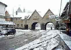
CITY TOUR:  Ushuaia, capital of Tierra del Fuego, it is located beside the Beagle channel and surrounded by the  Martiales mounts. The city offer an unique landscape because it is the combination of mountains, sea, glaciers and forest. Leaving the local port passing by the gangplank Luis Pedro Fique, crossing this narrow way we will arrive to the The Mission Neighborhood, elected place for the first white men that settled down in the area. Other neighborhoods to visit will be the Brown and Solier, inhabited by the first immigrants arrived in the first half of XX century . They will be been able to see the old houses belonging to the first  fueguinas families and to observe the contrast and the explosive growth taken place by the arrival of new residents starting from the '80. We will see the Legislature, old House of Government.  If the climatic conditions allows, it it will be been able to walk around the area of the base of the Martial Glacier. We will return for the avenue Leandro N. Alem, and toward the facilities of the Sea Museum and Former Prison of Ushuaia. After a short visit , we will go direct to the Museum of the End of the World, where great part of the fueguino past is counted. 

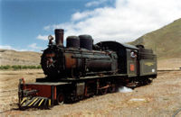
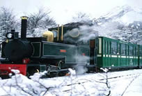
END of the WORLD TRAIN: Beside the valley of Pipo river, is   located the  Railroad station, after a brief visit for its facilities the convoy will be transit by the old layout that had the "train of the prison". Crossing bridges and with a stop  in the cascade of The Macarena. After a small description of the area, we will continue  entering at Tierra del Fuego national Park, toward where the old sawmill Lombardich was located and to the halt from the route Nº 3, where the tour concludes. 

SAILING by the BEAGLE CHANNEL (Island of  Wolves): Beginning the tour at the Touristic Port "Don Eduardo Arturo Brisighelli", along the coast of Ushuaia, it has a  view of the most important buildings of the city such as the Sea Museum (old prison), End of the World Museum. The industrial area was installed in 1980.
From this point, the landscape is a combination of sea and mountains, we can also see the mounts  Olivia, Cinco Hermanos, the ranchs Fique and Tunel, the Sharp mounts and the Encajonado River. From there, the tour goes to the center of the Channel, toward the Southwest, arriving at the Lighthouse Les Eclaireurs. In one of these islands it is possible to observe parts of the ship Monte Cervantes,  which was shipwrecked in 1930. 
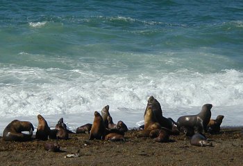
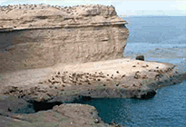
Toward the Island of the Wolves, we can enjoy the view of the games of these curious and nice marine mammals and in complete silence, to sail around the island for 20 minutes observing its permanent habitat. It is a wonderful scenary. Then the catamaran will go toward the Island of The Birds to see the Cormoranes Magallánicos and the Imperial ones, the Seabird, albatross, Giant Petrels, Squas and 20 different species of marine birds. Later, navigating through the Paso Chicowe begin  the return to  Ushuaia, with a view of the beautiful frame that gives to the city the Mount Martial and its glacier.  
Approximate duration: 02.30 hs. 

tierra

parqueushuaia

martial

parque

parquetierra

lagofag

canal

trenfindelmundo

lagoescondido

CONSULT!!!


Chubutense Coast Where the Nature reigns

PUERTO MADRYN: It has a population of approximately 50.000 inhabitants, most of them coming from the provinces  of the north starting from the creation of the factory of aluminum Aluar in 1974. The factory next to the fishing industry and the tourism constitutes its main source of economic revenues. It is located in the northwest of the province of Chubut from 1.400 Km.of Buenos Aires and it is the entrance door to the Peninsula and influenceareas. There are hotels of diverse categories but there are not 5 *, located in strategic points of the city. It receives tourism in two different seasons: Winter and spring is the season of whales and fauna, while the summer it will  transform  in a city with good temperature to enjoy its beaches. 
Its weather: Fresh winters but not with temperatures under zero. Windy springs with moderate temperatures to cold. Hot summers with something of wind ending up averaging the 30° and  moderate autumns.

PENINSULA VALDÉS: It is located in the northwest of the province of the Chubut. It has a surface of 4000 km2,  a coast of 110 Km  open to the sea and 150 Km in waters of the Gulfs Nuevo and San José. The nearest city is “Puerto Madryn” and it has an only center town that is the Villa of “Puerto Piramide”. More than 90% of its extension are fields of private property dedicated to the extensive breeding of the livestock ovino. It is a semi-arid atmosphere with a precipitation of approximately 300 mm per year. The temperature in winter is cold but not with temperatures under zero. The spring is cold with strong winds. The summer is warm and  moderate autumns. The waters of the Gulfs Nuevo and San José have temperatures in winter near to 14ºC and in summer near 17 grades. In spring it is used for fauna tourism (to sight whales, elephants, wolves, etc.) and in summer “Puerto Piramide” becomes a place spa. “Peninsula Valdés” offers to the visitor a great quantity of natural and historical attractiveness. The posts of marine elephants, wolves and marine birds make it an incomparable destination for its wealthy fauna and the easiness to access to her. In the interior it meets a great quantity of wild fauna with gumps, choiques, maras, rodents, birds, reptiles and the vegetation of the steppe patagónica. Each coast hides treasures and  incredible scenaries that make it an endless destination of knowing.
Although a regular circuit of one day has settled down, it is impossible to have in so few time a completed idea of what this enormous natural park means. 

PUNTA DELGADA : It is located in the southeast end of  “Peninsula Valdes”. This is an Army recycling construction that becomes a hotel and restaurant where they offer services of first level. Under the cliffs there are several posts of marine elephants from the south. It is the area with bigger concentration of marine elephants from the Atlantic Sea. There arenot faunas-guards and theprotection of the animals, as the entrance of tourists it is controlled for the staff of the tourist complex. 

CALETA VALDÉS : The reservation is located in a point called Punta Cantor. It is a  marine elephants post. It exists a fauna-guard, sanitariums and  drinks and foods stand. Besides the elephants, the attractiveness of this reservation it constitutes  the geologic formation and the landscape of  Caleta Valdés that extends for 35 Km., from this point toward the north. It is a good place to observe elephants, marine birds, the external coast and occasionally whales and marine wolves 

PUNTA NORTE: It is a reservation located in the northwest end of  “Peninsula Valdés”. You can access from Punta Cantor to the south or from “Puerto Piramide” to the west. In both cases there are rubble roads. There is a distance of 80 Km. from Piramide and it is not a reservation usually used by the regular tours. There there is a post of marine wolves from december until march and at the same time whales appears around the beach. The whales are occasional, they will eat marine wolves, and the probability of observing them is near 10%. 

PUERTO PIRÁMIDE : The Reservation is located in the tip that takes its name in the Gulf  Nuevo, at 100 Km. From Pto. Madryn. It is a post of marine wolves. At only 5 Km.from  the village of Pto Piramide, place from where there are frank whales. The village has near 100 permanent inhabitants which lives mainly from the tourism industry. There are foods Stand, lodging,, restaurants and several operators to sight whales, to carry out diving tours or for fishing. In summer it becomes a beach village. 

PENINSULA FULL TOUR:  You can feel the nature in the Humanity's  Natural Patrimony of “Peninsula Valdés”.  In the morning we leave  Puerto Madryn toward the North for the provincial route N°1,  stops then at 17 Km. to connect with the provincial route N°2. and traveling about 77 kms. you arrives to the Isthmus Carlos Ameghino, entrance door to the Reservation of Peninsula Valdés where we visit  the Center of Interpretation of the geography, flora, fauna and history of  Carlos Ameghino place. Continuing 20 Km. for the same route, we stray toward the east in order to reach Caleta Valdés, continental post of marine elephants, where we will be able to observe  these magnificent animals in full stage of skin reproduction. Continuing for the provincial route N° 47 we arrives to the Lighthouse of Punta Delgada, which presents characteristic peculiar to be the only place on the east riverbank of the Peninsula.
We return to  Puerto Piramide, we enjoy a lunch with typical plates of the region and we will see the  whales in a boats. To conclude the trip, you would be arriving to the city of Puerto Madryn in hours of the afternoon.  
Duration of the trip: 11 hours.  Journey: approx. 400 Km. 

valdez2
piramide2
valdez4
valdez3
piramide
valdez

CONSULT!!!


Tournée Viajes & Turismo

info@tournee.com.ar